![]() |
Cliffs Features:Shallow-Water approximation with an option to manipulate numerical dispersion Use of Cartesian or spherical (lon/lat) coordinates 1D and 2D configurations, including 1-D channels with varying width - domain type is detected automatically Structured colocated grid with (optionally) varying spacing Runup on land Variety of starting/forcing options: bottom deformation, surface deformation, boundary input, or combination of those Output options: various Grid nesting with one-way coupling Parallelized with OpenMP NetCDF format of input/output data |
Misc: |
Modeling Example 1 (Runup onto a sloping beach) Runup onto beach: 0.0185d (QuickTime mov) |
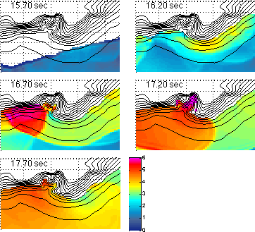
Modeling Example 2 (Hokkaido 1993 (Okushiri) Tsunami) Runup onto beach: 0.3d (QuickTime mov) |
Utilities: |
NetCDF QuickLook Plugin for Mac
DEM converter: ARC ascii to NetCDF |
References: |
E. Tolkova.
Land-Water Boundary Treatment for a Tsunami Model With Dimensional Splitting Pure and Applied Geophysics, Vol. 171, Issue 9 (2014), pp. 2289-2314 Cliffs on CSDMS E. Tolkova Comparative simulations of the 2011 Tohoku tsunami with MOST and Cliffs ArXiv, 2013 E. Tolkova Cliffs Benchmarking ArXiv, 2016 |
Copyright: |
Cliffs is copyrighted under the terms of FreeBSD (2-Clause) License |