Could a numerical tsunami match the records well, if it originated in a wrong basin?


Maximum wave amplitude. Computed with Cliffs

This page displays the results of virtual forecasting of the Oct. 28, 2012 tsunami generated by Mw 7.7 earthquake near the coast of British Columbia. The tsunami wave was estimated Pacific-wide based on the tsunami observations at DART 46419, models representing PMEL's "unit" earthquakes, and an original algorithm to construct the source. The computations were performed with Cliffs.

Reliable estimation of a tsunami source function (that is, the initial displacement of the sea surface from which the tsunami originated) presents a challenge for tsunami forecasting. PMEL's forecasting methodology approximates the tsunami source with a combination of models representing "unit" earthquakes with a fault length of 100 km, fault width of 50 km, and a slip value of 1 m, equivalent to a moment magnitude of 7.5 each. This apparently coarse size is dictated by both the limitations of the numerical method and the need to reduce uncertainties when fitting a DART record with the models.

The tsunami source was constructed from the PMEL's "unit" sources using my model-combining algorithm. Offshore wave heights were refined with higher resolution modeling at a few coastal sites where I had the grids handy, to enable comparison with tide gage records of the tsunami.
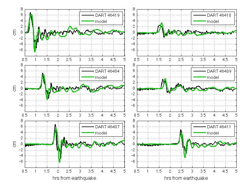
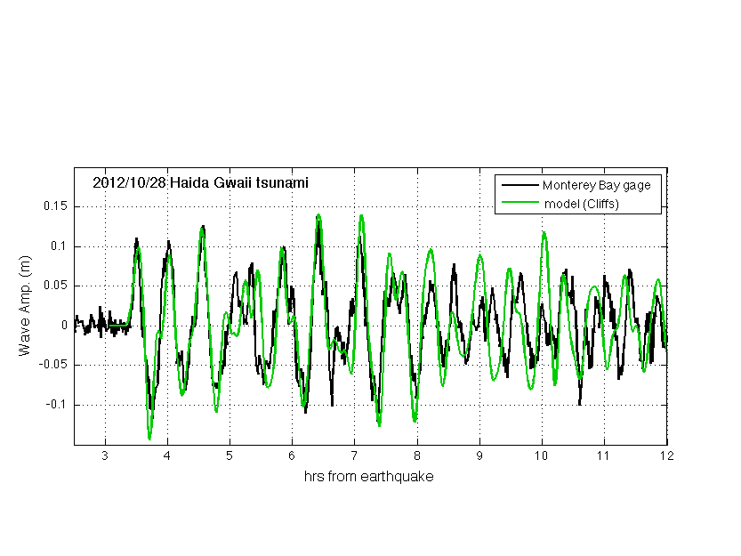
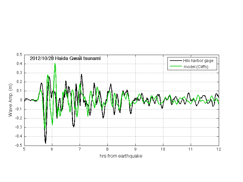
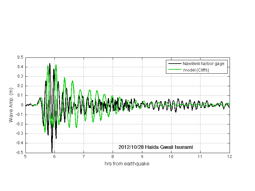
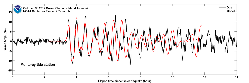
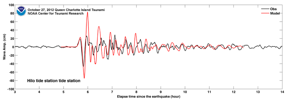
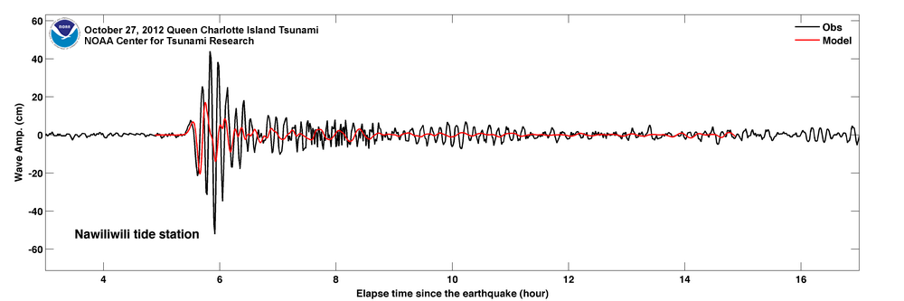
Model-to-measurements comparison plots:
  • DARTs
  • Monterey, CA
    Note: Monterey grids are not a SIFT forecast model.
  • Sitka, AK
  • Hilo, Big Island, HI
  • Nawiliwili, Kauai, HI
  • For reference, forecasting results by PMEL:
  • DARTs
  • Monterey, CA
  • Sitka, AK
  • Hilo, Big Island, HI
  • Nawiliwili, Kauai, HI
  • Ratio of predicted Maximum-Wave-Height to recorded Maximum-Wave-Height at the sites, as seen in the comparison plots
    Conclusions:

    1. The waveforms forecasted here approached records at DART stations much better than the PMEL's forecast did - the latter tends to die before the second wave peak (see Cliffs paper for why Cliffs did the better job). Consequently, the better agreement at the coastal sites is observed.

    2. Both the forecast provided by PMEL and the one presented here placed the major slip in PMEL's unit source a51 (see plot on the left). Thus in both cases, the inverted tsunami source is on the wrong side of the southern Haida Gwaii island.
    This is an occurence of the DART-constrained inversion repeatedly pointing to the wrong source area.
    Initial conditions for simulating the tsunami are provided as sea surface displacement and currents 30 minutes after the quake, in three netcdf data files (download below).
    Surface displacement download
    Zonal velocity download
    Meridional velocity download
    When using data/graphics from this page, please credit Elena Tolkova, NWRA